Metar-Taf - Visual decoder
- 4.8
- Rating
- 10.00K
- Installs
- $5.99
- Price

 Analysis by App-foxy
When I first opened Metar-Taf, I approached it with a very specific problem: aviation weather reports are useful, but their abbreviations can turn a quick check into a decoding exercise. This is a paid weather app from Studio Eveline that focuses on making METAR and TAF information easier to read visually. That narrow purpose is also its main appeal. It is not trying to replace every weather tool on my phone; it is aimed at the moment when I need to understand an airport observation or forecast without manually translating every group of letters and numbers.
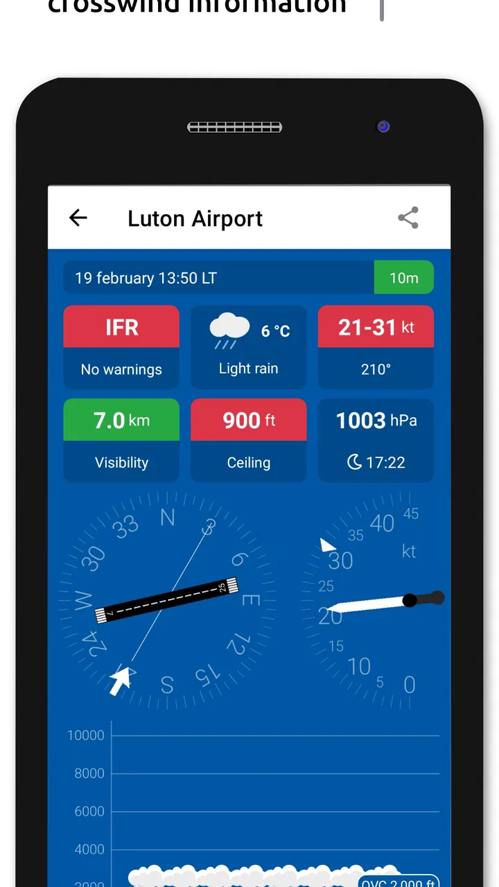
My overall impression is that the app makes the first step of reading aviation weather less intimidating. The store summary describes aviation weather as simple and presents the product as a visual decoder, and that matches the way I used it: I treated it as a translation layer between raw aviation reports and a more approachable overview. The experience is particularly relevant to student pilots, aviation enthusiasts, flight-planning learners, and anyone who regularly encounters METAR or TAF reports but does not yet read them fluently.
From a raw report to a usable weather picture
I find the most useful way to approach a METAR or TAF decoder is to treat it as a shared reference point, not as a substitute for anyone’s judgement. In a household or study group, one person can bring up a report while another follows the decoded weather picture, making it easier to discuss what the report means before moving on to the next planning step. That distinction matters even more when the people sharing a device have different levels of aviation experience.
You May Also Like

 Blood Strike: 2.5 Anniversary
Blood Strike’s Loadouts Turn Every Drop Into a Tactical Gamble
A close look at Blood Strike’s custom loadouts: how fast access to signature weapons reshapes its battle royale rhythm, rewards preparation, and narrows the gap between fights.

 Pandora - Music & Podcasts
Pandora’s Music Is Easy to Start, but Harder to Recover
Pandora’s strength is its low-effort path from a seed to a station. Its weak spot is how much confidence it asks you to place in connection, setup, and quiet recovery.

 8 Ball Pool
 Is Built on Rivalries, Rematches, and Routine
A close look at the rivalries, rematches, shared routines, and unanswered safety questions that turn a quick pool match into a persistent mobile community.

 Samsung Music
’s Quiet Strength Is Playing What You Already Own
Its reach comes less from spectacle than from dependable access to a personal library. That simplicity is both the app’s strongest retention engine and its ceiling.

 AccuWeather: Weather Radar
AccuWeather Review: A Quick, Clear Forecast for Everyday Decisions
For everyday plans, the best forecast is the one you can understand quickly. AccuWeather makes rain timing, radar, and local conditions easy to act on, with a few trade-offs.

 Hill Climb Racing
Why Hill Climb Racing Still Turns Crashes Into One More Run
A tiny car, a bumpy hill and one more upgrade: Hill Climb Racing keeps resurfacing because its simple chaos makes every near-miss feel personal.
More From Our News Desk
View All News


The starting condition: useful information hidden in a compact format
A METAR can look like an uninterrupted code when you are still learning the structure. A TAF adds another layer because it describes expected changes over time rather than only reporting current conditions. In a normal workflow, I might begin with a weather source, copy a report, search for explanations of each group, and then try to rebuild the meaning in my head. That is manageable for one report, but it becomes tiring when comparing several airports or checking the same route more than once.
That is where this app has a clear role. Instead of presenting aviation weather as an ordinary consumer forecast, it concentrates on the language pilots and aviation students actually encounter. The useful question is not simply “Will it rain?” but “What do the wind, visibility, cloud layers, present weather, and forecast changes mean for this airport and this period?” A visual decoder helps me move from recognition to interpretation without pretending that the underlying report is irrelevant.
I also like that the app’s purpose is specific rather than overloaded. Many general weather applications are excellent for temperature, radar, hourly conditions, or outdoor planning, but they usually do not explain aviation report syntax. Conversely, some aviation resources assume that I already understand the code. This app sits between those two extremes: it is more specialized than a normal weather app and more approachable than a raw-report-only tool.
The first step: entering the aviation weather information
My practical workflow starts with the report itself. I use the app when I have a METAR or TAF to inspect and want a clearer reading of its parts. The key habit is to treat the visual result as an explanation of the report, not as an independent replacement for checking the original text. That distinction matters because aviation weather is compact by design, and learning to connect the decoded display with the source report is more useful than memorizing a colorful screen.
For a beginner, I would recommend opening one familiar airport report first rather than jumping straight into a complicated route. Look at the displayed information, then compare the major elements with the original report one by one. This creates a small learning loop: identify the airport and time, inspect the wind, check visibility and weather, then move to clouds and any forecast changes. The app becomes more valuable when I use it to understand why a report says something, not merely to obtain a quick visual answer.
That approach is one of the less obvious strengths of a decoder. It can reduce the mental load while still leaving room for learning. If I always rely on a simplified presentation without looking at the source, I may become comfortable with the screen but remain uncertain when faced with a report elsewhere. Used alongside the raw report, the app is more educational and more transferable.
Reading the visual breakdown step by step
The central experience is the conversion of dense METAR and TAF notation into information that can be scanned in a more natural order. I find that helpful because aviation reports are not written like a sentence. The eye has to jump between groups, and a visual arrangement gives each part a clearer place in the overall picture.
I usually read the result in layers. First I establish the basic context: which airport or station the report concerns and when it was issued. Then I focus on wind because it affects runway use and the general operational picture. After that, visibility and present weather help me judge how clear or restricted the conditions are. Cloud information comes next, since the height and coverage of cloud layers can be more operationally meaningful than a simple “partly cloudy” label in a consumer forecast.
TAF reading requires a slightly different rhythm. I do not treat it as a second version of the METAR. The observation tells me what is being reported now, while the forecast requires attention to changes and periods. A useful workflow is to first understand the current baseline, then examine the forecast groups for transitions. When I use a visual decoder this way, I am less likely to confuse current conditions with what is expected later.
The best result comes from using the display as a map of the report, not as a substitute for aviation judgement. That is especially important for anyone making real flight decisions. A decoded presentation can improve comprehension, but it does not remove the need to understand local procedures, official briefing requirements, current updates, or the significance of the conditions for the particular aircraft and operation.
A realistic everyday scenario: preparing for a lesson
Imagine that I am preparing for a flight lesson and want to check the departure airport before leaving home. I have a METAR and a TAF available, but the coded strings are not yet comfortable to read. With this app, I can inspect the current observation first, identify the wind and visibility, and then look at the forecast for changes during the planned period. If the forecast contains a deterioration or a notable shift, I have a clearer reason to discuss the situation with an instructor instead of arriving with only a vague impression from a general weather icon.
The handoff here is important. The app helps me move from a report to a conversation. I can use the decoded view to organize questions: Is the wind likely to become unsuitable for the planned runway? Are the clouds expected to lower? Is the forecast change temporary or part of a broader trend? The final decision still belongs to the appropriate pilot or instructor, but the app makes the briefing more concrete.
For an aviation student, this workflow also turns routine checking into practice. Rather than studying isolated examples, I can compare what the raw report says with what the visual decoder presents, then gradually try to predict the meaning before looking at the explanation. That is a more useful habit than simply searching for a definition every time an unfamiliar group appears.
Handoffs between the app, other tools, and human judgement
No single weather application should carry the entire aviation briefing process, and this one is most convincing when treated as one part of a chain. I might begin with an official or familiar source for the report, use the decoder to understand the format, and then return to the source or another aviation resource for wider context. The app’s value is strongest in the middle of that process, where interpretation is the obstacle.
This also explains why it compares differently with ordinary weather apps. A normal forecast app may give me a cleaner answer for daily life: temperature, precipitation, wind direction, and an hourly timeline. If I only need to decide whether to walk, commute, or carry an umbrella, this specialist tool is unnecessary. But those consumer summaries can hide the details that matter in aviation, while a raw aviation source can be too compressed for a learner. Metar-Taf occupies the educational and interpretive space between them.
It also differs from a full flight-planning platform. A broader aviation service may be preferable when I need route planning, alerts, charts, airport information, or an integrated briefing workflow. This app’s focused design is an advantage when decoding is the immediate problem, but that focus becomes a limitation when I expect a complete operational dashboard. I would not buy it assuming that one specialized decoder will replace every aviation resource I already use.
What the result is actually good for
The result I get is a more readable understanding of METAR and TAF content. That sounds modest, but it solves a real friction point. I can spend less time looking up abbreviations and more time asking whether the conditions fit the plan. For someone learning aviation weather, the visual structure can also make recurring patterns easier to recognize.
The app is particularly useful when the report is unfamiliar, when I am comparing current conditions with a forecast, or when I want to explain the report to someone who understands basic weather but not aviation shorthand. It can also serve as a quick refresher before studying, because the visual representation helps connect terminology with the actual coded groups.
Its audience is not limited to pilots. Aviation students, flight-simulation users who want to understand realistic weather reports, instructors preparing examples, and enthusiasts following airport conditions may all find a focused decoder worthwhile. The Everyone content rating makes it broadly accessible from an age-classification perspective, although the subject itself is specialized and assumes an interest in aviation.
Learning without losing the original meaning
One trade-off deserves attention: simplification can improve access while reducing the feeling of direct contact with the report. When I read a raw METAR, I am forced to notice its order and syntax. When I read a visual interpretation, I can understand the conditions faster but may overlook how the information was encoded. I see this as a reason to alternate between both views rather than choosing only one.
A practical method is to cover the decoded result mentally and attempt a first reading of the raw report. Then I use the app to check my interpretation. Over time, I can make the app less of a crutch and more of a verification tool. This is one of the strongest ways to get lasting value from it, especially if the goal is to become comfortable with aviation weather rather than simply obtain a one-time translation.
Another useful habit is to read the forecast in relation to a specific time window. Instead of asking whether the TAF is “good” or “bad,” I look for what changes before, during, and after the planned activity. The app can make those transitions easier to notice, but I still need to connect them with the schedule and operational context outside the screen.
Where the workflow breaks down
The first limitation is scope. If I want a complete weather picture with radar, satellite imagery, long-range trends, severe-weather alerts, or a polished everyday forecast, I would choose a broader weather service. A METAR and TAF decoder is not the right tool for every weather question. Its specialization is helpful only when the question is specifically about aviation reports.
The second limitation is that visual clarity does not automatically equal operational completeness. A report can be easier to understand and still require careful interpretation. Local terrain, runway orientation, aircraft performance, pilot experience, NOTAMs, alternate planning, and changing observations all exist beyond the decoder. I would never treat a simplified display as permission to proceed or as a replacement for a proper briefing.
There is also a learning trade-off for experienced users. If I already read METAR and TAF fluently, the visual layer may add little and could even slow me down when I only want the original string. The app is more compelling for learners and occasional readers than for someone who has built a fast, independent decoding workflow.
Finally, the paid price changes the decision. At $5.99, I would expect a clear personal use case rather than buying it casually as another general weather app. The cost is easier to justify if I regularly study aviation weather or need help interpreting reports. Someone who checks airport conditions only once in a while may prefer existing free resources and learn the code gradually without adding a dedicated purchase.
Who should install it, and who should pass
I would recommend it to a student pilot who wants a friendlier bridge into aviation weather, especially if raw reports still feel like a wall of abbreviations. It also makes sense for aviation enthusiasts who want to understand the reports behind airport conditions, and for anyone who benefits from seeing information organized visually before returning to the original code.
I would be more cautious recommending it to professional users who already have an established briefing system. In that situation, the app may be a convenient teaching aid, but it is unlikely to replace the tools and procedures already used for operational decisions. I would also skip it if my weather needs are entirely ordinary: daily temperatures, rain chances, pollen, storms, or weekend planning are better served by a conventional weather application.
The current release is version 2.8.0 and it runs on Android versions from 7.0 onward, which makes it accessible to people using older compatible devices. Studio Eveline has kept the concept focused rather than turning it into a broad weather suite. That focus is exactly why I can understand its appeal, but it also means the purchase should be based on the METAR and TAF decoding workflow itself.
My final take after following the full workflow
Metar-Taf works best when I start with a confusing aviation report, use the app to separate its pieces, compare the current observation with the forecast, and then hand the result back to a proper planning or teaching process. It reduces the first barrier without pretending that aviation weather can be reduced to a single icon or yes-or-no answer.
The app has earned a 4.8 average from around 1.1 thousand ratings, with over 10 thousand installs, which fits my impression that it serves a clearly defined audience well. Those figures are not a reason to ignore the limitations, but they do suggest that the focused approach resonates with people who need this particular kind of help. Its release date was August 28, 2021, and the current version shows that it remains an actively identifiable tool rather than an abandoned experiment.
My recommendation is straightforward: buy it if decoding METAR and TAF reports is the part of aviation weather that repeatedly slows you down. Use it as a learning aid, a checking step, and a way to prepare better questions for an instructor or pilot. Do not buy it expecting radar, route planning, or a complete flight briefing. For the right user, Metar-Taf is a practical visual bridge between coded reports and informed understanding; for everyone else, a regular weather app will probably be the better fit.
FAQs for Metar-Taf - Visual decoder
01What is Metar-Taf - Visual decoder used for?
Metar-Taf - Visual decoder is designed to help pilots, aviation students, flight planners, and enthusiasts understand METAR and TAF weather reports. Instead of presenting only the compact coded messages, the app translates important information into a more readable visual format, including wind, visibility, clouds, temperature, pressure, and forecast trends. It can make aviation weather information easier to interpret at a glance.
02Does Metar-Taf - Visual decoder support both METAR and TAF reports?
Yes, the application is intended to work with both METAR observations and TAF forecasts. METAR reports describe current or recent conditions at an airport, while TAF reports provide a forecast for a specific period. The visual presentation can be especially useful for comparing present conditions with expected changes, although users should always confirm the original coded report and official aviation weather sources before making operational decisions.
03Is Metar-Taf - Visual decoder suitable for student pilots and beginners?
The app can be helpful for beginners because it presents aviation weather information in a less intimidating way than raw coded reports. Visual indicators and organized sections make it easier to connect abbreviations with real weather elements. However, it should be used as a learning and reference tool rather than a replacement for formal meteorology training, instructor guidance, or the official briefing procedures required for safe flight planning.
04Can I rely on the app for flight planning and aviation safety decisions?
Metar-Taf - Visual decoder may assist with quickly reviewing weather information, but it should not be the only source used for flight planning or safety-critical decisions. Weather data availability, update timing, network access, interpretation errors, and local reporting limitations can affect the result. Pilots should verify conditions through official aviation weather services, current briefings, NOTAMs, and applicable regulations before departure.
05Does Metar-Taf - Visual decoder require an internet connection?
An internet connection may be necessary when the app retrieves current METAR or TAF reports from online aviation weather services. Previously viewed information may remain available depending on the app’s caching behavior, but users should not assume that stored data is current. Before relying on any displayed report, check its observation or forecast time and make sure the application has successfully refreshed the latest available information.
Pros
- Quickly decodes METAR and TAF reports into an easy visual format.
- Useful for pilots needing weather information at a glance.
- Supports aviation-specific details such as wind
- visibility
- and cloud layers.
- Visual presentation helps reduce confusion when reading raw weather codes.
- Practical offline access may be available for previously loaded reports.
Cons
- Coverage and report availability depend on the selected airport and data source.
- Some decoded terms may still require basic aviation weather knowledge.
- The interface can feel utilitarian compared with more modern weather apps.
- Forecast interpretation is limited to METAR and TAF information.
- Advanced pilots may miss radar
- satellite
- and broader weather-map features.

Metar-Taf - Visual decoder
Gallery